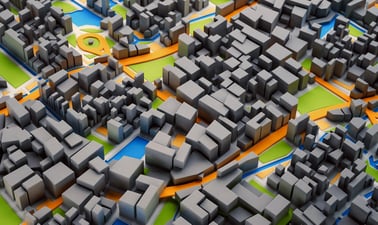
Ir al contenido principal

AlaskaX: 3D GIS

4.3 stars
6 ratings

Take your maps into the third dimension: Learn GIS concepts and tools to visualize, analyze, and interpret spatial data in 3D. Reveal patterns that can lead to better decision making.

3D GIS
4 semanas
3–5 horas por semana
A tu ritmo
Avanza a tu ritmo
Gratis
Verificación opcional disponible

Hay una sesión disponible:

Una vez finalizada la sesión del curso, será archivadoAbre en una pestaña nueva.
Comienza el 19 abr
Termina el 31 jul

Sobre este curso

Omitir Sobre este curso

Maps are graphic representations of reality and help us understand and navigate the world around us. Maps can incorporate third dimension through contours, hillshading (3D modeling), and profile views.

In this course you will learn fundamentals of third dimension (3D) GIS concepts and tools to visualize, analyze, and interpret geospatial data in 3D, enabling you to reveal patterns and relationships for more effective problem-solving and decision making.

When the data include the third dimension, ArcGIS Scene allows us to navigate through the data in 3D space. This makes the data and the problem more understandable and reveals new visual insights. Visualizing and processing the data in 3D allows us to include real-world elements in the analysis such as undulation of terrain and 3D extent of trees, building, and subsurface geology.

Our world is three dimensional and many GIS applications now require 3D analysis. Esri’s ArcGIS Scene allows us to visualize data on a world sphere. It provides a variety of tools for orientation, navigation, search, data preparation, building workflows and spatial analysis.

3D mapping and visualization is used in a variety of industries and academic disciplines:

  • Monitoring forest stand height and age
  • Volumetric analysis of resource extraction from a mine or water level in a reservoir
  • Watershed delineation to assess inundation risk, land management, environmental monitoring

Verified track learners will receive one-year ArcGIS Pro Desktop (Windows) license with support only for tools used in the course in addition to unlimited course access and a verified certificate.

Sign up for this online course or full GIS Essentials certificate today to expand your skillset in geographic information systems.

De un vistazo

  • Institution AlaskaX
  • Subject Ingeniería
  • Level Intermediate
  • Prerequisites

    GIS1x: Geographic Information System (GIS) Foundations is highly recommended and precedes this course in the edX GIS Professional Certificate.

    Windows OS is required to run ArcGIS Pro software.

  • Associated programs
  • Language English
  • Video Transcripts English, Español
  • Associated skillsProblem Solving, Decision Making, Spatial Analysis, Land Management, Visualization, Workflow Management, Spatial Data Infrastructures, 3D Modeling, ArcGIS (GIS Software), Geographic Information Systems, Cartographic Relief Depiction (Cartography), Geology, Mapping, GIS Applications

Lo que aprenderás

Omitir Lo que aprenderás
  • How to display and navigate 3D data in ArcGIS Scene
  • How to edit and process 3D feature data
  • How to carry out volumetric analysis
  • How to display and process elevation raster (DEM: Digital Elevation Model) data
  • Watershed mapping and delineation using a DEM
  • Visualization of 3D feature and raster data in ArcScene

Plan de estudios

Omitir Plan de estudios

Week 1: 3D GIS Introduction

  • What is 3D GIS?
  • How does a GPS work?
  • Digital Elevation Model
  • Remote sensing technologies to obtain a DEM
  • Open source DEM products
  • Access to ArcGIS Pro software

Week 2: 3D Feature and Elevation Raster Analysis

  • 3D feature data and analysis
  • DEM processing and analysis
  • Volumetric analysis
  • Visualizing 3D feature and raster data in ArcScene
  • ArcGIS Pro Best practices

Week 3: Watershed Delineation

  • Introduction to Watershed
  • Access open source DEM data from USGS Earth Explorer
  • Preparing DEM for watershed analysis
  • Delineate watershed from DEM (compare to a real river)

Week 4: Tree Height Analysis from LiDAR Data

  • Introduction to LiDAR
  • Process LiDAR data in ArcGIS Pro
  • Estimate tree canopy height and map tall trees using LiDAR data

Testimonios de los estudiantes

Omitir Testimonios de los estudiantes

This course covers such a range of useful applications I hadn't previously considered using ArcGIS for, and does so in a simple and straight forward manner. Its an excellent continuation of the skills developed in GIS1x. –Verified track learner

It is really nice that this is self-paced and those that are teaching the subject are very detailed and show everything they do step by step. –Verified track learner

Well taught course. Demonstrations are easy to follow and the theory behind each geoprocessing tool is well explained. –Arnold Tanondong, verified track learner

The instructions are extremely thorough and provided in multiple formats (text and video) making them very accessible. –Verified track learner

Este curso es parte del programa Geographic Information Systems (GIS) Essentials Professional Certificate

Más información 
Instrucción por expertos
3 cursos de capacitación
A tu ritmo
Avanza a tu ritmo
3 meses
3 - 5 horas semanales

¿Te interesa este curso para tu negocio o equipo?

Capacita a tus empleados en los temas más solicitados con edX para Negocios.